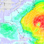
Invest 96L continues to meander toward coast
It doesn’t appear that Invest 96L is in any hurry to get to where it wants to go. The tropical wave is still a tropical wave and is still slowly moving toward the Bahamas. Latest model data suggests that shear may inhibit development during the next 6 – 18 hours, but that eventually that atmosphere will be conducive to strengthening…. Read more →

