Primary Menu Search
  • About us
    • About us
    • How We Forecast
    • Archives
  • Our Services
    • Live Stream: Severe Weather Discussions
    • Go Storm Chasing
    • Pictures
  • Contact Us!
  • Jobs
  • Weather Safety
    • Weather Safety
    • Hurricane Preparedness Tips
    • Road Conditions
    • Current Conditions
    • South Mississippi river forecasts
    • Forecasting Presentation
  • Login

NickelBlock Forecasting

Funny name. Serious data.

Secondary Menu
  • Severe Weather Outlook
    • Severe Outlook through Day 8
    • Severe Outlook By State
    • Today’s Severe Weather Threat
    • Today’s Tornado Threat
    • Today’s Severe Wind Threat
    • Today’s Severe Hail Threat
    • Excessive Rainfall Forecasts
  • Short Term Forecast
    • Current Radar & Satellite
    • Detailed National Forecast Discussion
    • National Surface Maps
    • National Temperatures
    • National Precipitation Chances
    • National Precipitation Estimates
    • National Snowfall Estimates
    • National Ice Estimates
    • National Convective Outlook
    • Public RAPTOR Map
    • Model Data Viewer
  • Tropics
  • 10 Day Trend
  • Seasonal Discussion
You are here: Home ∼ Page 1432
UPDATE: Blizzard Watches & Warnings issued for Major NE hubs, New York City, Boston

UPDATE: Blizzard Watches & Warnings issued for Major NE hubs, New York City, Boston

Nick Lilja Sunday, January 25, 2015 // 10:22 am

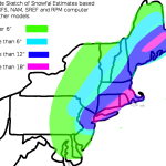
UPDATE (1/25/15 11:00pm): Here is the latest graphics from the 21z SREF (for Boston and NYC), 0z GFS and 0z NAM: It will be interesting to see where the most intense snow bands occur. Depending on which model you look at, you get a little bit of a different answer. The 0z NAM seems to have a decent handle on… Read more →

Posted in Archive, Northeast Weather | Tagged Blizzard, Blizzard2015, Boston Weather, cold, National Weather Service, Northeast Weather, NYC Weather, snow, weather

SPC MD 42

Alomar Sharpe Saturday, January 24, 2015 // 11:54 am

MD 0042 CONCERNING HEAVY SNOW FOR COAST OF MAINE MESOSCALE DISCUSSION 0042 NWS STORM PREDICTION CENTER NORMAN OK 1053 AM CST SAT JAN 24 2015 AREAS AFFECTED…COAST OF MAINE CONCERNING…HEAVY SNOW VALID 241653Z – 242300Z SUMMARY…HEAVY SNOW IS EXPECTED TO DEVELOP ALONG THE COAST OF MAINE THIS AFTERNOON. SNOWFALL RATES SHOULD REACH 1 INCH PER HOUR IS SOME SPOTS WITHIN… Read more →

Posted in Archive, Severe Weather Discussions | Tagged Severe Weather, Watches and Warnings, weather

SPC MD 41

Alomar Sharpe Saturday, January 24, 2015 // 5:48 am

MD 0041 CONCERNING HEAVY SNOW FOR PORTIONS OF MA…RI…NERN CT…AND SRN NH MESOSCALE DISCUSSION 0041 NWS STORM PREDICTION CENTER NORMAN OK 0447 AM CST SAT JAN 24 2015 AREAS AFFECTED…PORTIONS OF MA…RI…NERN CT…AND SRN NH CONCERNING…HEAVY SNOW VALID 241047Z – 241645Z SUMMARY…HEAVY SNOW WILL CONTINUE TO OVERSPREAD PORTIONS OF SERN NEW ENGLAND OVER THE NEXT SEVERAL HOURS. LOCAL SNOWFALL RATES… Read more →

Posted in Archive, Severe Weather Discussions | Tagged Severe Weather, Watches and Warnings, weather

SPC MD 40

Alomar Sharpe Saturday, January 24, 2015 // 2:31 am

MD 0040 CONCERNING SEVERE POTENTIAL…WATCH UNLIKELY FOR COASTAL AREAS OF WEST-CENTRAL TO SOUTHWEST FL MESOSCALE DISCUSSION 0040 NWS STORM PREDICTION CENTER NORMAN OK 0130 AM CST SAT JAN 24 2015 AREAS AFFECTED…COASTAL AREAS OF WEST-CENTRAL TO SOUTHWEST FL CONCERNING…SEVERE POTENTIAL…WATCH UNLIKELY VALID 240730Z – 241000Z PROBABILITY OF WATCH ISSUANCE…20 PERCENT SUMMARY…A MARGINAL THREAT FOR A BRIEF TORNADO EXISTS DURING THE… Read more →

Posted in Archive, Severe Weather Discussions | Tagged Severe Weather, Watches and Warnings, weather

SPC MD 39

Alomar Sharpe Friday, January 23, 2015 // 11:49 pm

MD 0039 CONCERNING HEAVY SNOW FOR PORTIONS OF CNTRL AND ERN PA…CNTRL/NRN NJ…SE NY INCLUDING NYC AND LONG ISLAND…PORTIONS OF CT MESOSCALE DISCUSSION 0039 NWS STORM PREDICTION CENTER NORMAN OK 1048 PM CST FRI JAN 23 2015 AREAS AFFECTED…PORTIONS OF CNTRL AND ERN PA…CNTRL/NRN NJ…SE NY INCLUDING NYC AND LONG ISLAND…PORTIONS OF CT CONCERNING…HEAVY SNOW VALID 240448Z – 241045Z SUMMARY…HEAVY… Read more →

Posted in Archive, Severe Weather Discussions | Tagged Severe Weather, Watches and Warnings, weather
← Previous 1 … 1,431 1,432 1,433 … 2,028 Next →

Today’s Severe Weather Threat

SVR WX THREAT

Today’s Tornado Threat

SVR WX THREAT

Search The Site

Contributing Scientists

  • Alomar Sharpe
  • Amber Kulick
  • Branden Walker
  • Chris Vagasky
  • Colt Murray
  • Emily Riter
  • Kendall Junker
  • Matt Breland
  • Nick Lilja
  • NickelBlock Staff
  • Noah Gower

Wx Topics

2019 Atlantic Hurricane Season 2020 Atlantic hurricane Season Alabama Weather Amarillo weather Atlantic Hurricane Season Coronavirus COVID-19 COVID19 Earthquakes Flooding Geology Gulf Coast Weather hail hurricanes Louisiana Weather Mississippi Weather rain Severe Weather snow Texas Weather Thunderstorms Tornadoes Tropical Depressions Tropical Storms Tropical Weather tropics USGS Watches and Warnings weather Wind

What We Cover

  • Archive (10,136)
  • Climate (64)
  • Education (230)
  • Environment (8)
  • Forecasting (467)
  • Geology (210)
  • High Plains Weather (119)
  • Midwest Weather (35)
  • Northeast Weather (13)
  • Northwest Weather (5)
  • Not Weather (93)
  • Research (31)
  • River Flooding (23)
  • Severe Weather Discussions (8,640)
  • South Plains Weather (69)
  • Southeast Weather (312)
  • Space (19)
  • Storm Chasing (86)
  • Tropics (450)
  • Weather & Sports (4)
  • Weather & TV (37)
  • Weather History (8)
  • West Coast Weather (4)

Research

  • Conclusion: How multiple variables control TX/OK panhandle Spring severe weather
  • Findings: How multiple variables control TX/OK panhandle Spring severe weather
  • Methods: How multiple variables control TX/OK panhandle Spring severe weather
  • Introduction: How multiple variables control TX/OK panhandle Spring severe weather
  • Works Cited: How multiple variables control TX/OK panhandle Spring severe weather

Popular This Month

  • Remember that “Arctic Blast” people were posting about? Buckle up (6,957)
  • Another “Arctic Blast!” headed to the southeast says social media-rologists (2,420)
  • Arctic blast plunges Mississippi into ice age-like conditions colder than one of the moons of Jupiter (2,410)
  • More cold and snow has South Mississippi feeling like South Manitoba (1,888)
  • More wintry weather possible in South Mississippi next week (1,854)
  • Enough with the “Meteorologists get paid to be wrong” (1,617)
  • Afternoon Update: Snow possible for South Mississippi (960)
  • CIPS Analogs showing thunderstorms, possible severe weather, late next week for south Mississippi (949)
  • Freezing weather won’t kill all mosquitos (664)
  • Jan 16, south Mississippi morning snowfall update (541)
  • Instantly freeze water to make stalagmites (333)
  • Will it snow? A brief look at the steps to get it (318)

Primary Menu

  • About us
    • About us
    • How We Forecast
    • Archives
  • Our Services
    • Live Stream: Severe Weather Discussions
    • Go Storm Chasing
    • Pictures
  • Contact Us!
  • Jobs
  • Weather Safety
    • Weather Safety
    • Hurricane Preparedness Tips
    • Road Conditions
    • Current Conditions
    • South Mississippi river forecasts
    • Forecasting Presentation
  • Login

Secondary Menu

  • Severe Weather Outlook
    • Severe Outlook through Day 8
    • Severe Outlook By State
    • Today’s Severe Weather Threat
    • Today’s Tornado Threat
    • Today’s Severe Wind Threat
    • Today’s Severe Hail Threat
    • Excessive Rainfall Forecasts
  • Short Term Forecast
    • Current Radar & Satellite
    • Detailed National Forecast Discussion
    • National Surface Maps
    • National Temperatures
    • National Precipitation Chances
    • National Precipitation Estimates
    • National Snowfall Estimates
    • National Ice Estimates
    • National Convective Outlook
    • Public RAPTOR Map
    • Model Data Viewer
  • Tropics
  • 10 Day Trend
  • Seasonal Discussion

Copyright © 2026 NickelBlock Forecasting.

Powered by WordPress and Path. Back to Top

Google+
  • About us
  • Our Services
  • Contact Us!
  • Jobs
  • Weather Safety
  • Login