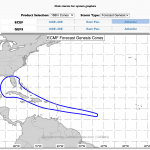
Invest92L still getting organized, models uncertain
It is a good news, bad news situation. The good news is that Invest 92L is taking “longer” to get developed and organized. Originally in the 2-to-5 day window, Day Five would’ve been today. And while there is still time for it to develop a low-level center of low pressure, the likelihood is on the lower end of the scale…. Read more →
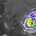
7/24/20 AM Tropical Update: Douglas, Gonzalo, Hanna, and the next Wave – with model data!
Not much has changed overnight, thankfully. There have been little tweaks to some of the forecasts, and the model data has come into better agreement in some places. But no drastic changes. The “biggest” change is likely with Gonzalo. More on that below! Here is a look at the big picture. Notice how big and small some of the features… Read more →
WX Info: The MJO, Kelvin Waves and Hurricane Season
On the air last night, I mentioned a Kelvin Wave. Your browser does not support the video tag. These things are pretty cool. And pretty important when it comes to forecasting during hurricane season. The MJO and Kelvin waves can help dictate how – generally speaking – likely tropical development may be on a non-specific basis. However, I don’t usually… Read more →
7/24/20 Tropical Weather Update – Douglas, Gonzalo, Hanna & the next Wave
The tropics remain reasonably active as we move through the end of July. Not to say there are multiple monster Hurricanes, but two Tropical Storms and another wave coming off of Africa. Tropical Storm Hanna is in the Gulf of Mexico. Tropical Storm Gonzalo is out in the open Atlantic east of the Windward Islands. And the next wave after… Read more →

