NOAA Storm Prediction Center – No Mesoscale Discussions are in effect as of Thu Jul 7 04:30:05 UTC 2016
No Mesoscale Discussions are in effect as of Thu Jul 7 04:30:05 UTC 2016. Powered by WPeMatico
No Mesoscale Discussions are in effect as of Thu Jul 7 04:30:05 UTC 2016. Powered by WPeMatico
WW 343 SEVERE TSTM KS NE 070245Z – 070800Z URGENT – IMMEDIATE BROADCAST REQUESTED SEVERE THUNDERSTORM WATCH NUMBER 343 NWS STORM PREDICTION CENTER NORMAN OK 945 PM CDT WED JUL 6 2016 THE NWS STORM PREDICTION CENTER HAS ISSUED A * SEVERE THUNDERSTORM WATCH FOR PORTIONS OF NORTH CENTRAL KANSAS CENTRAL NEBRASKA * EFFECTIVE THIS WEDNESDAY NIGHT AND THURSDAY MORNING… Read more →
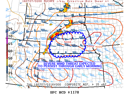
MD 1178 CONCERNING SEVERE POTENTIAL…WATCH LIKELY FOR CNTRL AND ERN NEB…NRN KS MESOSCALE DISCUSSION 1178 NWS STORM PREDICTION CENTER NORMAN OK 0928 PM CDT WED JUL 06 2016 AREAS AFFECTED…CNTRL AND ERN NEB…NRN KS CONCERNING…SEVERE POTENTIAL…WATCH LIKELY VALID 070228Z – 070430Z PROBABILITY OF WATCH ISSUANCE…95 PERCENT SUMMARY…THE THREAT OF SEVERE WINDS AND HAIL IS EXPECTED TO PERSIST THIS EVENING INTO… Read more →

Public Severe Weather Outlook PUBLIC SEVERE WEATHER OUTLOOK NWS STORM PREDICTION CENTER NORMAN OK 1234 PM CDT WED JUL 06 2016 …Severe thunderstorms expected over parts of the northern and central Plains this afternoon and tonight… * LOCATIONS… South Dakota Northeastern Nebraska Far northwestern Iowa Far southwestern Minnesota * HAZARDS… Widespread damaging winds, some hurricane force A couple of tornadoes… Read more →

Public Severe Weather Outlook PUBLIC SEVERE WEATHER OUTLOOK NWS STORM PREDICTION CENTER NORMAN OK 1234 PM CDT WED JUL 06 2016 …Severe thunderstorms expected over parts of the northern and central Plains this afternoon and tonight… * LOCATIONS… South Dakota Northeastern Nebraska Far northwestern Iowa Far southwestern Minnesota * HAZARDS… Widespread damaging winds, some hurricane force A couple of tornadoes… Read more →

