You can get the latest details from all of the great meteorologists in the Northeast via Twitter – right here:
Tweets from https://twitter.com/nqlblq/lists/northeast-meteorologists
MD 0043 CONCERNING HEAVY SNOW FOR ERN LONG ISLAND / CAPE COD AND PORTIONS OF ERN MA / RI / SERN CT MESOSCALE DISCUSSION 0043 NWS STORM PREDICTION CENTER NORMAN OK 0533 PM CST MON JAN 26 2015 AREAS AFFECTED…ERN LONG ISLAND / CAPE COD AND PORTIONS OF ERN MA / RI / SERN CT CONCERNING…HEAVY SNOW VALID 262333Z -… Read more →
You can get the latest details from all of the great meteorologists in the Northeast via Twitter – right here:
Tweets from https://twitter.com/nqlblq/lists/northeast-meteorologists
To steal a phrase from WTNH’s Chris Velardi – good morning early risers and up-all-nighters! Here are my latest thoughts on the blizzard. Monday 12pm: Light snow begins falling in New York City and points south and west. Winds will be gusty, but not bad, sustained around 15mph. Still dry to the northeast. Monday 6pm: Heavier snow falling in New… Read more →
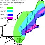
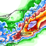
UPDATE (1/25/15 11:00pm): Here is the latest graphics from the 21z SREF (for Boston and NYC), 0z GFS and 0z NAM: It will be interesting to see where the most intense snow bands occur. Depending on which model you look at, you get a little bit of a different answer. The 0z NAM seems to have a decent handle on… Read more →
MD 0042 CONCERNING HEAVY SNOW FOR COAST OF MAINE MESOSCALE DISCUSSION 0042 NWS STORM PREDICTION CENTER NORMAN OK 1053 AM CST SAT JAN 24 2015 AREAS AFFECTED…COAST OF MAINE CONCERNING…HEAVY SNOW VALID 241653Z – 242300Z SUMMARY…HEAVY SNOW IS EXPECTED TO DEVELOP ALONG THE COAST OF MAINE THIS AFTERNOON. SNOWFALL RATES SHOULD REACH 1 INCH PER HOUR IS SOME SPOTS WITHIN… Read more →

