M 6.9 – 142km NE of Ndoi Island, Fiji
Time 2014-11-01 18:57:22 UTC 2014-11-01 06:57:22 -12:00 at epicenter Location 19.733°S 177.750°W Depth 416.00 km (258.49 mi) Powered by WPeMatico
Time 2014-11-01 18:57:22 UTC 2014-11-01 06:57:22 -12:00 at epicenter Location 19.733°S 177.750°W Depth 416.00 km (258.49 mi) Powered by WPeMatico
MD 1900 CONCERNING HEAVY SNOW FOR PORTIONS OF THE SIERRA NEVADA MOUNTAINS IN E-CNTRL CA ABOVE 6500 FT MESOSCALE DISCUSSION 1900 NWS STORM PREDICTION CENTER NORMAN OK 1140 PM CDT FRI OCT 31 2014 AREAS AFFECTED…PORTIONS OF THE SIERRA NEVADA MOUNTAINS IN E-CNTRL CA ABOVE 6500 FT CONCERNING…HEAVY SNOW VALID 010440Z – 010945Z SUMMARY…HEAVY SNOW WILL DEVELOP OVER PORTIONS OF… Read more →
I know, I know. You’re all shocked.Apparently those giant tornado killers would only spawn different tornadoes and landspouts in other areas. Oh, and turn the midwest into a desert. Brice Evan Coffer just published a paper in the E-Journal of Severe Storms Meteorology explaining that the giant walls would ultimately fail and cause more harm than good. The only thing… Read more →
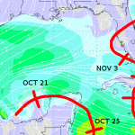
As November inches closer, the chances of tropical systems developing continues to diminish. And it is diminishing rapidly. But we’re not out of the woods just yet. A new cluster of storms is churning through the Gulf and the National Hurricane Center is giving it a 30- to 50-percent chance to develop into a tropical depression. The latest 0z GFS… Read more →
MD 1899 CONCERNING SEVERE POTENTIAL…WATCH UNLIKELY FOR CNTRL MD INTO SERN PA MESOSCALE DISCUSSION 1899 NWS STORM PREDICTION CENTER NORMAN OK 1220 PM CDT WED OCT 15 2014 AREAS AFFECTED…CNTRL MD INTO SERN PA CONCERNING…SEVERE POTENTIAL…WATCH UNLIKELY VALID 151720Z – 151945Z PROBABILITY OF WATCH ISSUANCE…20 PERCENT SUMMARY…AN ISOLATED STRONG WIND GUST OR BRIEF/WEAK TORNADO CANNOT BE RULED OUT WITH STORMS… Read more →

