Southern Mississippi river levels as of March 15, 2018 at 12:59 am
Below are the southern Mississippi river stage forecasts as issued by the National Weather Service offices of Jackson, MS, Mobile, AL and Slidell, LA. :
Below are the southern Mississippi river stage forecasts as issued by the National Weather Service offices of Jackson, MS, Mobile, AL and Slidell, LA. :
The next system isn’t set to swing through at a typical angle, and that means the severe weather threat continues to diminish – though it won’t be zero. The area may see a few storms Saturday afternoon and evening. Most of these will be regular storms. Some may be on the strong side. But the threat for severe weather doesn’t… Read more →
As another storm system swings by to our north, it will open the door for showers and storms to develop Saturday afternoon. Most of these will be regular storms. Some may be on the strong side. But the severe weather threat doesn’t really arrive until we get into the overnight hours on Saturday night into Sunday morning. Timeline in a… Read more →
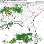
There is the threat for thunderstorms this evening for South Mississippi, but – in general – the severity of the storms will be quite limited. The main risk area will be west of the area. The Breakdown Storms will develop to the west and swing through South Mississippi between 8pm and 4am. Some of these storms will be supercells that… Read more →
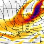
Taking a look at the CIPS Analogs this morning, a trend of “slowly increasing storm risk” finally got to a breaking point, and it is time to pass along the threat: South Mississippi is looking at the threat for storms and severe weather three of the next six days. What DOES this mean? This DOES mean that storms are possible…. Read more →

