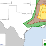
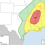
Here is a look at the severe weather threat for Monday. Give it a few seconds to load, it is pulled from Facebook…

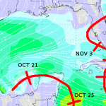
As November inches closer, the chances of tropical systems developing continues to diminish. And it is diminishing rapidly. But we’re not out of the woods just yet. A new cluster of storms is churning through the Gulf and the National Hurricane Center is giving it a 30- to 50-percent chance to develop into a tropical depression. The latest 0z GFS… Read more →

UPDATE 11:55am: The SPC is now considering a tornado WATCH for sections of the area. Details here The SPC is recognizing the evolving nature of this severe weather event and moved the areas of concern for this afternoon farther south. The 10 percent tornado threat now looks like it noses into northwest sections of the Pine Belt. And while you… Read more →

UPDATE: The 11am update for this event is located here Before I hit the sack… The SPC just released the 6z forecast for Monday and it looks like this: The first thing you may notice is that for the Pine Belt and most sections of southern Mississippi the roughest weather is to the north. But don’t let your guard down. The… Read more →
Here is a look at the severe weather threat for Monday. Give it a few seconds to load, it is pulled from Facebook…
The threat for severe weather across the Pine Belt isn’t terribly high as we move through Thursday and Friday – but it is the first time we will be dealing with the chance for organized severe weather in quite some time. Here is a look at some of the behind the scenes stuff we look at to forecast the weather!… Read more →